(Orinally written in September, 1994.)
In the late 1930’s, the village of Avon had a population of about 600 people. Most had lived in Avon, also known by the Indian name of Kinnakeet, for generations. Past generations were fishermen, but the establishment of the US life saving stations in 1874 along the Outer Banks changed the livelihoods of many local men. At the lifesaving stations they served as surfmen and keepers, utilizing their generational knowledge of the treacherous sea. The US Coast Guard took over the life saving service in 1916. Little Kinnakeet station was in service until 1955, and many local men were stationed there at various times. This station can still be seen and is located about 3 miles north of Avon.
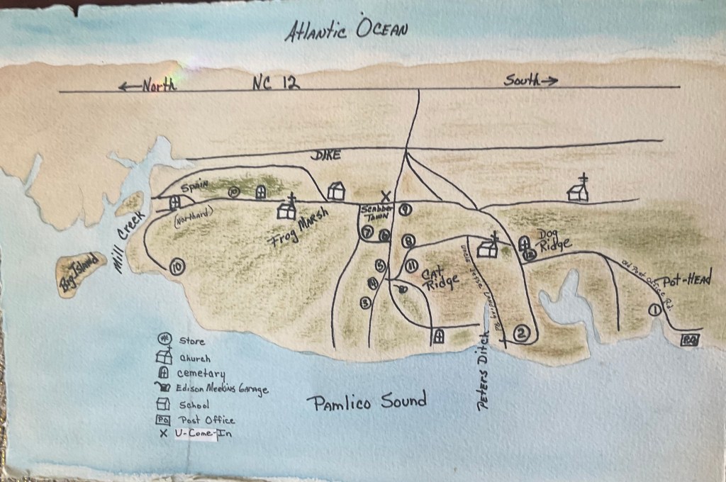
The roads were unpaved until 1952 and some were scarcely more than sandy tracks traveled for years by horse and cart. Many locals owned automobiles which traveled the sometimes soft and sandy roads at the owner’s peril. The Coast Guard personnel often assisted the traveling public through the deep sand. Avon had the only car repair shop on Hatteras island , owned by Edison Meekins.
The village was served by about 12 stores offering everything from bolts of fabric to a cold bottle of Coca-Cola. Stores were owned by C. T. Williams, Lorenzo Gray, Amblic Price, Lloyd Meekins, Richard Gray, Andrew Meekins, E. F. Scarborough, George O’Neal, Frank Williams, Fields Meekins, Calvin Meekins, and Gibb Gray. “Ball Band” shoes and boots could be purchased from Fields Meekins’ store. Mr. Meekins also had a freight house on Mill Creek and brought in goods on his own boat the Ruth. He had salvaged shipwrecks as well, selling whatever was marketable. Richard Gray’s store was a popular hangout to play pool and have a cold bottle of pop along with a pack of nabs. The You-Come-In along the main road coming into the village served beer and had a jukebox. Andrew Meekins’ store also had a jukebox and was a hangout for the young people. The first telephone in Avon was at Gibbs Gray’s store; the phone number was Avon-102. His store became a center of information and gathering spot for locals and visitors. The village did not have electricity at that time but the stores gradually had their own generators.
There were three churches at that time, the oldest being St. John’s Methodist Episcopal Church South. This church had been established in Avon for over 100 years. There was also a Northern St. John’s which came about because of splits in the Methodist denomination over slavery. It has since been recombined. The Avon Worship Center, an Assembly of God church, was established in 1931. It has since been moved into its present location across from the harbor. The harbor did not exist until 1946, when the US Army Corps of Engineers dredged it. The diking on the east and south side of Avon was dug in the 1930s to keep the sea tides out. It served its purpose fairly well until the hurricane of September 1944 which flooded and devastated the village with sound and ocean tide. The tide was the highest from that storm since the San Ciriaco hurricane of 1899. Many families moved away from Hatteras island after the storm of 1944.
Areas of the village had curious names, the most reasonable being the “Norther’d” for the north part. This area was also called “Spain”, because probably because it was the farthest walk from the rest of the village. Other names were “Frog Marsh”, “Cat Ridge”, and “Dog Ridge”. “Pothead” was the southern part of the village. The origination of these names is unclear. There was a certain amount of rivalry between these areas and a few fistfights from time to time among groups of boys. The only area named for the family living there was “Scabbertown” for the Scarboroughs who were concentrated on one road near the middle of the village. The Avon school was “up the norther’d” and served all grades with a teacher for each elementary grade and two for high school. There were about 7 cemeteries in the village including the old O’Neal cemetery where the Food Lion is now. This area was known as the “Souther’d”. There is a mass grave located southwest of the main road as it comes over the dike. This grave was used to bury remains that were washed out of cemeteries by the San Ciriaco hurricane.
The map accompanying this article represents Avon as it was in the 1930’s and was pieced together with the help of many locals and drawn by local artist Denise Gaskins. (Denise passed away on May 7, 2024.)